
Description
Manufacturer: AirPixel
The RFD DIN-IO-US Interface Bundle is an industrial-grade telemetry input/output solution designed for reliable data communication in demanding environments. Featuring fully isolated interfaces, this system provides secure and noise-resistant connectivity between remote devices over long-range RF links.
Each DIN-IO-US unit includes two fully isolated digital inputs and two fully isolated clean-contact relay outputs, enabling bidirectional telemetry and remote control functionality. The integrated isolated RS485 / RS422 interface (user-configurable) makes this system well-suited for industrial and electrically noisy environments where signal integrity is critical.
DIN-IO units operate in pairs to create a complete telemetry bridge between two locations. Ordering and deploying in matched pairs is recommended for proper operation.
This bundle includes two DIN-IO-US interfaces along with matched antennas, RF adapters, and extension cables to support flexible installation and antenna placement.
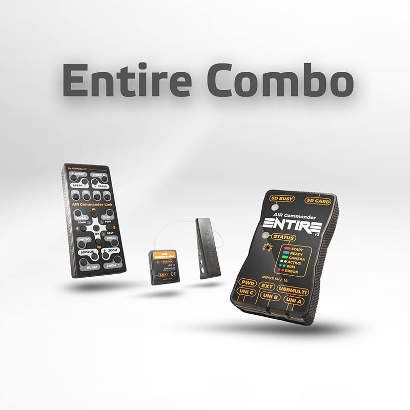
Entire Combo contains:
- AIR Commander Link v2
- AIR Commander ENTIRE R3
- Connection cables (Link-Entire)
Compatibility:
- Sony *
- Nikon **
- Canon
- Panasonic GH & S & BGH1
- FujiFilm (GFX50R/50R/GFX100)
- Z-CAM
- BlackMagic (BMPCC4k/6k, URSA Mini Pro)
- Sony Venice (LAN) / FX6 (LANC)
- RED (including new KOMODO)
- PhaseOne Industrial (with iX Link terminal)
- PhaseOne IQ digital backs
- Marshall (all cameras with RS485 terminal)
*RX1RM1, RX1M1, RX100(r1) are not supported.
*MENU and navigation is available only for cameras with IR sensor (A6*, A7*, A9*)(For Newest A7* models without IR sensor you can use A9 SmartPlug for MENU&Navigation control).
**For the Nikon D850 shutterspeed is only available in range of 1/30 – 1/8000. ISO, Aperture and other are fully configurable.
Geotagging for DJI M600 or PixHawk & Sony cameras:
ENTIRE supports writing of GPS / RTK and Gimbal angles* information from your flight controller (A3/N3/M300/PixHawk) controller directly to the EXIF of photos in the camera SD card. Alternatively can be GPS data stored to the microSD card inserted in the SD slot of ENTIRE. When PixHawk is connected, you can easily trigger photographs via MAVlink from your RC controller or mission event. If the DJI flight controller is used, you can use Fport shutter for triggering camera in mission or manual flight.
*gimbal angles are available only for DJI flight controllers used with DJI gimbal or Gremsy v2/v3 series gimbals and also for PixHawk drones with Gremsy v2 or v3 gimbals.
EXIF is written with an extremely high accuracy of 0.00000001 degrees, which is approx. 1mm accuracy in the distance. Altitude is saved with 0.1mm accuracy. Gimbal angles (Roll/Pitch/Yaw) are available only when DJI gimbal is used.
The camera must support “Mass Storage” USB connection for direct EXIF upload of GPS (or RTK) data. Currently, all Sony cameras support the “Mass Storage” mode.
Geotagging process:
In the moment of takeoff, the ENTIRE is opening the camera via USB and gets the latest file number. During the flight is ENTIRE capturing each photo with GPS coordinates. In the moment of landing will ENTIRE opens the Camera again and upload all metadata right to the EXIF of each photo (JPG or ARW). Our method is very fast and usually takes only a few seconds, for example geotagging of 100 photos taken during the flight takes less than 8 seconds (RAW or JPG).
More information about geotagging
More information about HereLink & PixHawk camera control.
